Receiving DGPS Stations with MultiMode For Mac OS X

MultiMode for Mac OS X can decode DGPS (Differential Global Positioning System) transmissions. DGPS stations transmit the difference between positions indicated by GPS satellite systems and the known fixed position of the station. This allows higher accuracy. DGPS transmissions are 100 or 200 baud and are transmitted on frequencies from 285 kHz to 325 kHz. They can be interesting DX targets.

A copy of MultiMode can be downloaded here: http://www.blackcatsystems.com/download/multimode.html

To decode the transmission, tune your radio to a DGPS frequency. You can either tune directly to the frequency in CW mode, in which case you set the center frequency in MultiMode to that for your radio’s CW mode, or use USB mode, tune 1 kHz low, and set the center frequency to 1000 Hz.

You can listen to an example DGPS audio recording

Select the baud rate, either 100 or 200 baud, using the button. Also be sure to set your location so that the correct distance and bearing is calculated. Eventually, if you have tuned into a DGPS transmission that is strong enough, you will start seeing decode messages printed:

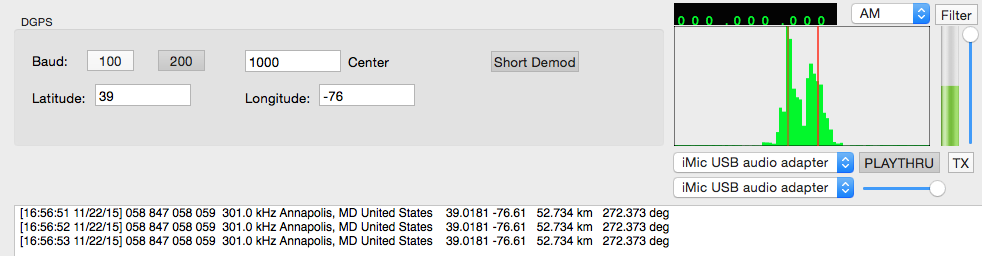
The Short Demod button can be toggled on, in which case MultiMode will look at a smaller part of the DGPS packet. This often allows decodes of weaker transmissions.

Note that since no error checking is performed on the packet, it is possible to get false decodes. To help determine if you are actually receiving the correct station, compare the printed frequency for that station to what your radio is tuned to, to verify they match. Also look for several decodes from the same station in a row, that indicates that you probably are really receiving that station.

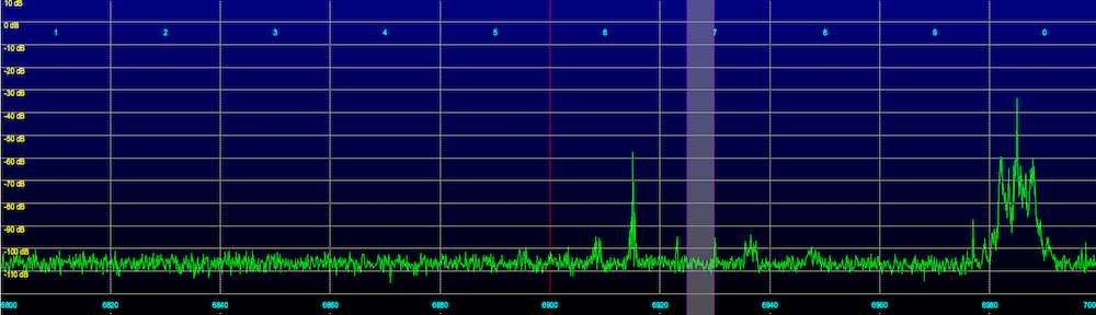
Here’s a list of some stations I have received here with a modest 200 ft random wire antenna:

[15:44:47 11/19/15] 008 804 008 009 286.0 kHz Sandy Hook, NJ United States 40.4747 -74.0197 235.632 km 45.2895 deg
[19:27:49 11/19/15] 198 772 198 199 306.0 kHz Acushnet, MA United States 41.7492 -70.8886 529.571 km 53.1416 deg
[19:28:52 11/19/15] 190 782 190 191 305.0 kHz Dandridge, TN United States 36.0225 -83.3067 723.745 km 245.071 deg
[19:29:12 11/19/15] 156 863 156 157 311.0 kHz Rock Island IL United States 42.0203 -90.2311 1245.06 km 290.156 deg
[19:32:00 11/19/15] 012 806 012 013 289.0 kHz Driver, VA United States 36.9633 -76.5622 231.719 km 192.449 deg
[19:33:00 11/19/15] 184 788 184 185 291.0 kHz Hawk Run, PA United States 40.8889 -78.1889 280.839 km 319.079 deg
[19:33:24 11/19/15] 006 803 006 007 293.0 kHz Moriches, NY United States 40.7944 -72.7564 340.978 km 53.1725 deg
[19:33:37 11/19/15] 196 771 196 197 294.0 kHz New Bern, NC United States 35.1806 -77.0586 434.825 km 192.789 deg
[19:33:50 11/19/15] 092 843 092 093 295.0 kHz St Mary's, WV United States 39.4381 -81.1758 448.281 km 277.867 deg
[19:33:54 11/19/15] 136 792 136 137 297.0 kHz Bobo, MS United States 34.1253 -90.6964 1414.92 km 252.075 deg
[19:33:59 11/19/15] 058 847 058 059 301.0 kHz Annapolis, MD United States 39.0181 -76.61 52.734 km 272.373 deg
[19:36:40 11/19/15] 046 824 046 047 303.0 kHz Greensboro, NC United States 36.0694 -79.7381 463.251 km 226.48 deg
[19:40:01 11/19/15] 218 777 218 219 304.0 kHz Mequon, WI United States 43.2025 -88.0664 1110.64 km 298.697 deg
[19:41:11 11/19/15] 130 834 130 131 307.0 kHz Hagerstown, MD United States 39.5553 -77.7219 160.52 km 293.159 deg
[19:43:59 11/19/15] 312 929 312 313 296.0 kHz St Jean Richelieu, QC Canada 45.3244 -73.3172 736.38 km 16.5642 deg
[19:44:05 11/19/15] 154 862 154 155 322.0 kHz St Louis, MO United States 38.6189 -89.7644 1190.3 km 272.301 deg
[19:55:36 11/19/15] 112 836 112 113 292.0 kHz Cheboygan, MI United States 45.6556 -84.475 1013.8 km 319.521 deg
[20:32:19 11/19/15] 017 808 016 017 314.0 kHz Card Sound, FL United States 25.4417 -80.4525 1560.45 km 196.764 deg
[20:34:44 11/19/15] 340 942 340 341 288.0 kHz Cape Ray, NL Canada 47.6356 -59.2408 1650.3 km 49.1252 deg
[22:10:54 11/19/15] 168 869 168 169 290.0 kHz Louisville, KY United States 38.0175 -85.31 816.337 km 265.238 deg
[22:11:34 11/19/15] 192 778 192 193 292.0 kHz Kensington, SC United States 33.4906 -79.3494 681.801 km 207.126 deg
[22:20:26 11/19/15] 320 925 320 321 313.0 kHz Moise, QC Canada 50.2025 -66.1194 1464.05 km 28.7438 deg
[11:34:56 11/20/15] 262 881 262 263 302.0 kHz Point Loma, CA United States 32.6769 -117.25 3697.45 km 272.2 deg

Seasonal Pirate Radio Stations

Tune into the 43 meter pirate radio band, which is roughly 6800 to 7000 kHz, but 6925 kHz in particular, on any given evening, and you’re likely to hear one or more broadcasts. While many stations transmit throughout the year, there are a few seasonal stations that you will only hear on certain days. To help you keep track of these stations, here’s a short summary of the more widely reported seasonal pirates. Note that the schedules of pirate radio stations are very flexible, and often broadcasts of these seasonal stations will be heard on a nearby weekend instead of the actual holiday, when there are usually more listeners.

I’ve also included QSLs from some of the stations.

WMLK – Recordings of speeches by Martin Luther King Jr, usually around his celebrated birthday, the next is January 18, 2016.

Voice of Pancho Villa – Heard during the time the NASWA Winter SWL Fest, which is usually in February.

WPDR Presidents’ Day Radio – Heard around Presidents’ Day with recordings of speeches by various Presidents. In 2016, Presidents’ Day is February 15.

Frederic Chopin Radio – Plays classical piano music, heard on our around his birthday of March 1.

XEROX – A classic parody of a Mexican radio station, usually on the air April Fools Day (April 1).

Radio Cinco De Mayo – Heard on or around the Mexican Holiday on May 5.

KHAQQ / Amelia Earhart Often heard on or around July 3, with simulated communications between ground station NRUI and Earhart (KHAQQ), trying to locate her.

Radio Paisano – A program of Italian related music which airs around Columbus Day, which is next observed October 10, 2016.

Halloween themed stations – Lots of stations are heard around Halloween, here’s several of the most active:
Peskie Party Halloween
Pumpkin Patch Radio
Radio Halloween
Satan Radio
The Great Pumpkin
WAHR Automated Halloween Radio
Witch City Radio


Edmund Fitzgerald Radio – Commemorates the sinking of the ship with the Gordon Lightfoot song as well as recordings of marine communications. Heard on November 10.

WJFK – Usually on the air around day of President Kennedy’s assassination, November 22. Traditionally, the station plays these three songs:
“Abraham, Martin & John” by Dion
“Sunny” by Bobby Hebb
“PT-109” by Jimmy Dean

Another variant has appeared in recent years, which plays recordings of news announcements of the assassination.

D. B. Cooper Radio – Heard on or around the day before Thanksgiving.
Related to the hijacking of a Boeing 727 on Wednesday, November 24, 1971.

Turkey Breast Radio – Heard on or around Thanksgiving.

Happy Hanukkah Radio – Heard during the eight days of Hanukkah. Usually the following is heard:
“Miracle of Miracles” from Fiddler on the Roof
“Hava Nagila” by the Effi Netzer Singers
“2000 Year Old man” skit by Mel Brooks.

Christmas themed stations – Another popular holiday for pirates:
Fruitcake Station
NOEL
Radio Jingle Bells
Snowball Radio

Irregular stations:

WUBR Ultimate Blizzard Radio – Occasionally heard during major snowstorms.

Victory Radio – Heard when University of Texas wins a football game.

Poor conditions for some on 43 meters last night, better for others

One measure of the strength of the ionosphere is called foF2. It is the maximum frequency that will be reflected straight back. That is imagine the radio transmitter and receiver are located near each other, the radio waves go straight up, and are reflected straight back down to the receiver. foF2 is continuously varying, based on solar activity, and what part of the Earth the Sun is over. You can find a real time map at this URL: http://www.spacew.com/www/fof2.gif

As the distance between the transmitter and receiver increases, the radio waves are not perpendicular to the ionosphere, but instead strike it at an angle. This allows frequencies higher than foF2 to be reflected. The angle that the radio waves strike the ionosphere depends on the distance between the transmitter and receiver, and the height of the ionosphere, which unfortunately also varies. This is called the hmF2, and there’s a real time map of it also: http://www.spacew.com/www/hmf2.gif

The Maximum Usable Frequency (MUF) can be found by:
MUF = foF2 * sqrt( 1+ [D/(2*hmF2)]^2) where D is the distance in km.

Lately, foF2 has been reaching very low values once the Suns sets. This is what causes the 43 meter band to “go long”, making it difficult to impossible to hear stations even many hundreds of miles away. As an example, here is a plot of the measured foF2 value taken over Wallops Island, VA. Consider these values typical for much of the eastern US during this time period:

The blue trace is today’s foF2 values, red is yesterday’s, and the green trace is an average of the last five days.

foF2 was about 5 MHz at 2300z, dropping to 4.5 MHz by 0000z. This was evident in the loggings for The Crystal Ship. Many listeners who normally get a strong signal from this station had poor or no reception (as was my case). This was also the start of a geomagnetic storm, the K index at 0000z was 3, and has since risen to 5 as I type this.

The flip side of a low foF2 value is that listeners at a greater distance from a station can get stronger signals. The geomagnetic storm last night could also have actually enhanced reception for some listeners. Medium wave DXers have referred to geomagnetic storms as “stirring the gumbo”, bringing in a different mix of station than are normally heard.

Update – here is the link to the real time Wallops Island foF2 chart: http://www.ngdc.noaa.gov/stp/IONO/rt-iono/realtime/WP937_foF2.png and the current graph itself: